Finding stars

Finding stars

Pencil and paper
Overview
Using this Resource
Connecting to the Curriculum
Marking Student Responses
Working with Students
Further Resources
This task is about identifying things on a map of the night sky.
How to do this task 

  • Take Star Map A outside to the middle of the playing field.
  • Imagine it is 10:00 p.m. at night in February.
 
a)
 
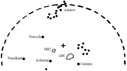
Hold Star Map A in front of you, and with your arm, point out to another student a place in the sky where you would see:
  • the Southern Cross
  • the Pointers
  • Canopus
  • Achernar
b) i)
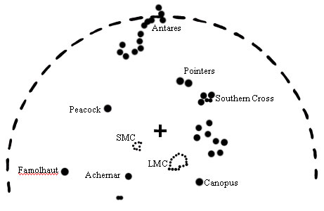
On Star Map A write the number 1 where you think the Southern Cross will be 2 hours later at midnight.
  ii)
Now write the number 2 where you think the Southern Cross will be at 2:00 a.m.
  iii)
Now write the number 3 on your map where you think the Southern Cross will be at 4:00 a.m.
 
c)
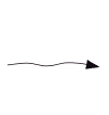
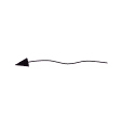
Which of these lines would you use to join your numbers in question b)?
 
 
(A)
(B)
(C)
(D)
(E)
d)
Use the line you chose in c) above, to join the numbers on Star Map A.
 
Star map A - SOUTH
New Zealand star map - south view for mid February at approximately 10:00 p.m.
star map
 
e)
 
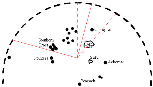
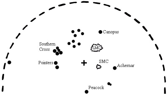
Below is another star map for a month later in the year, but the Southern Cross and the Pointers have been left out.
Draw an X on this star map to show the area where these would be.
 
 
Star Map B - SOUTH
(a month later)
 
star map
 
Task administration: 
Equipment:
Star map.
  • This task assesses students understanding of the night sky.
  • Part a) is done in pairs.
  • Copies of Star Map A are on a separate page.
  • Students will either need to work out where South is (i.e., use a compass), or be shown.
Level:
4
Description of task: 
This practical task requires students to use a simple star map to point out the apparent location of stars or star groups during daylight hours. Students also use the star map to show where the Southern Cross would be situated at different times of an evening.
Curriculum Links: 
Science capabilities
The capabilities focus is brought about by the conversations you have and the questions you ask.
 
Capability: Interpret representations
Scientists represent their ideas in a variety of ways, including models, graphs, charts, diagrams and written texts. This resource provides opportunities to discuss how to read a star map to locate and track constellations. (There are many explanations available on the web, e.g., http://www.richardbell.net/starmap.html, is very clear, but be careful that information is relevant to the southern hemisphere.)
Science capabilities: 
Answers/responses: 
a)  
  • The student points to their left when pointing to the place in the sky for the Southern Cross and the Pointers, and points to their right for Canopus and Achernar.
  • The student indicates through pointing that the Southern cross is higher in the night sky than the Pointers, and similarly Canopus is higher in the night sky than Achernar.
b)

i)
ii)
iii)

Numbers 1, 2, and 3 are in a left to right sequence.
Numbers are in a circular pattern.
The number 3 is placed within the dashed lines, see star map 1 below.

c)   D
d)  
Appropriate line drawn through numbered locations.
Star Map A
e)   An X drawn, which is within 4 mm of any star in the Pointers or the Southern Cross. See star map 2 for location of the Pointers and the Southern Cross.

Star Map B
Teaching and learning: 
Before exploring this assessment resource, students should have had experience looking at the night sky, identifying significant elements and noting how they move relative to the Earth.