The Tarawera eruption

The Tarawera eruption

Pencil and paper
Overview
Using this Resource
Connecting to the Curriculum
Marking Student Responses
Further Resources
This task is about interpreting a map and identifying issues about volcanic ash.

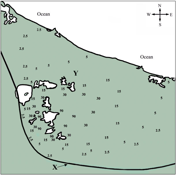
Below is a map of an area affected by ash fall from a volcanic eruption.

The numbers, e.g., 15, represent the limit of ash for that depth in centimetres (cm).
 

a)
Draw curved lines to join all the numbers which are the same, This will show the limits of ash for the five different depths.
(NOTE: You can draw lines through the lakes, but do not draw lines in the ocean. Draw lines to the coast or the edge of the map where appropriate).
 
b)
At point Y on the map, what would be the approximate depth of ash? __________ cm.
 
c)
What description about ash fall should be given to the line labelled X?  


d) i)
Draw a letter V on the map to show the point where the erupting volcano probably was located.
 
  ii)
What evidence did you use to decide on the location of this volcano?  


e)
 
From which direction was the wind probably blowing when this eruption occurred? 
 
____________________
 
f)
Explain three major problems this ash could cause if there were towns nearby.
 
  1.


  2.


  3.


Task administration: 
This task can be completed with pencil and paper only.
Level:
5
Description of task: 
Students are provided with a map that has numbers on it representing various ash fall depths from a volcanic eruption. Students draw lines to link the similar numbers and answer questions about these. They also explain three major problems an ash fall could cause.
Curriculum Links: 
Science capabilities
The capabilities focus is brought about by the conversations you have and the questions you ask.
 
Capability: Interpret representations
This resource provides opportunities to discuss the conventions of diagrams and how they clarify the meaning for the reader.
Science capabilities: 
Answers/responses: 


Y10 (11/2000)

a)

 
  • Curved lines drawn, lines go through all numbers, lines do not go in the ocean, lines do not cross over. (NOTE: where the lines are close at the bottom of the map, some leniency is required).
  • All of the above except one part not completed accurately. For numbers this would be a maximum of 3 missed.
  • All of the above except two parts not accurate.
  • All of the above except three parts not accurate.


NOTE: Each error type should only be penalised once.

4 correct – very difficult
 
3 correct – difficult
 
2 correct – easy
 
1 correct – very easy

b)


Any answer between 7 and 13 cm.

very easy

c)


Limit/edge of deposit/ash fall

difficult

d)

i)

ii)

V drawn anywhere within the shaded region. (See note at end of scoring guide).
Because the ash is thickest in this area.

easy

easy

e)


Southwest/SW.

difficult

f)


Any 3 of: 

  • The air would be difficult to breathe.
  • Roads would be difficult to drive on.
  • Poor visibility when driving.
  • Ash could contaminate water supplies.
  • Acid rain or a description of a problem associated with acid rain.
  • Other acceptable answers.

3 correct –
very difficult
 
2 correct –
moderate
 
1 correct –
easy

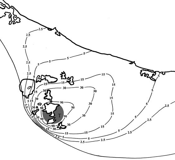
NOTE: Questions are based on ash fall from the Tarawera eruption of 1886. The location of Tarawera is marked with a T on the answer diagram.